Solomon Jennings, one of the three participants in the Walking Purchase of 1737, secured a warrant for 200 acres of land on the south side of the Lehigh River on March 5, 1736. He is one of the earliest residents of the Rittersville area. The Jennnings farm was located on both sides of the river, with the southern portion in Salisbury township. As early as 1737. Solomon Jennings provided a ferry service across the Lehigh River to connect a crude road from the Philadelphia road through Rittersville to Wind Gap.
Solomon Jennings died in 1757. In 1764, the heirs of Solomon Jennnings sold the property to Jacob Geisinger, of Upper Saucon Township, for $1500 and for decades thereafter, this land was known as the Geisinger farm. In 1792, Jacob sold his land, 502 acres, to his son, George. Jacob Geisinger died in 1815. Eventually the land was sold to the New Jersey Zinc Company, and then to the Lehigh Valley Railroad. I do not know who owns it today.
In June of 1789, an incident occurred at the farm. Here is the story as told by Charles Rhodes Roberts in a paper read in 1925 to the Lehigh County Historical Society:
In the year 1789, toward the end of June, George Geisinger's wife, Christiana, had a son born, named David. It was the custom in those days, when a child was born, for neighbors to bring, if a boy, a rooster, and, if a girl, a chicken, as a gift. Two neighbors, Daniel and Jacob Quier, had promised to bring such a gift, and when, one evening, the family, consisting of George Geisinger, his brother Jacob, aged 17, three serving lads, aged 15 to 20, and probably one or two girls were seated in the kitchen, paved with square bricks, when a knock on the door was heard. George Geisinger opened the door, thinking it was the two neighbors, when in walked two robbers, armed with guns and pistols.
The robbers forced all into the large fireplace and one remained on guard while the other went upstairs in search of the father, Jacob, and demanded his money. The old man, just awakened, said he would have to go downstairs for it. The two came down and when they arrived at the kitchen, George had seized an opportunity to throw the other robber to the floor. The robber who came down with Jacob, was named Sinclair, and he aimed his pistol at George's head, but it failed to go off, and he then hit George on the head with it. A general fracas then ensued, with the father, who was a strong man, then over 60, and the two sons; the apprentice boys, however, ran away. It is said that George's wife, even came from her two days' old child to assist.
Sinclair was bound, but the other robber escaped. He was taken to Easton and sentenced to ten years' hard labor. He escaped, but was recaptured and taken to Philadelphia in chains by my great-great-grandfather, George Graff, then Sheriff, and put on a prison ship. The gun taken is still owned by descendants. It was used in the Revolution and bears the stamp U. S. and is a flint lock.
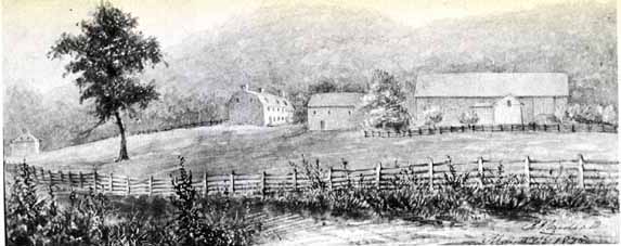
This view of the Geisinger farm, from 1851, shows the part of the farm that was on the north (Hanover Township) side of the Lehigh river, and the Lehigh Canal.
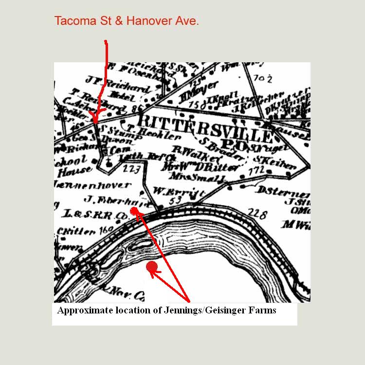
A rough idea of the location of the Geisinger farm, and the 1737 road from Philadelphia to Wind Gap, can be seen by driving to the top of either Sherman St and turning left, or to the top of Tacoma St. and turning right. The narrow road you are now on is E. Allen St. If you proceed a short distance along this road you will come to a blocked off, overgrown road heading down toward the river. If you look down toward the river, you will see the approximate location of the farm. The overgrown road you are looking at probably followed the path of the original 1761 road since it appears on maps that pre-date the establishing of Rittersville.
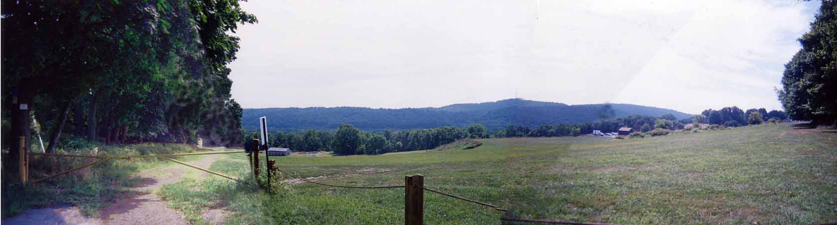
The bottom of the road shown above ends at River Road, a road that runs alongside the Conrail freight yards, Lehigh canal and Lehigh river. The exit of the above road onto River Rd is very difficult to find because of all the brush and weeds that have overtaken it. To attempt to view the bottom of this road, you need to access River Rd by driving to the top of Carlisle St and following the road to the left down along the railroad tracks. From Bethlehem, you can access this road along the river from W Market St. In Bethlehem, River Rd is known as Central Ave. The best time to go is in late fall after the leaves are off the trees.
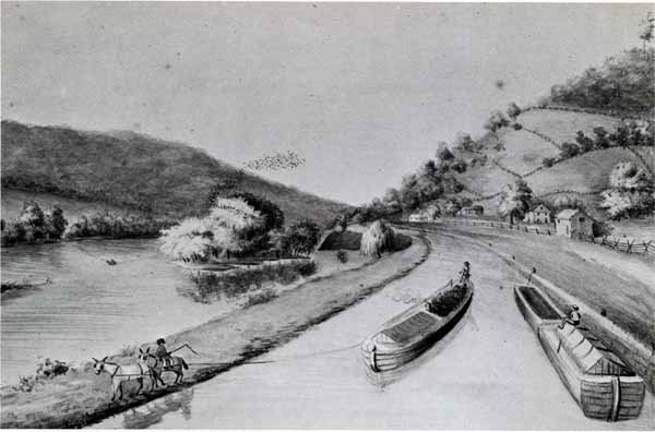
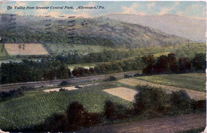
The road along the river was the site of many farms. In fact, most of the land you see in the picture above, and along River Road was cultivated land. Much of the forest you see along the road and up the mountain today grew there over the last 75 to 80 years after the farms were abandoned. Note all the cultivated land in the photos below.
 |
 |
1913 - View southwest from part way down the road shown in the 2005 photo above. Former Geisinger farm in the distance, canal in the center of the photo, river beyond. |
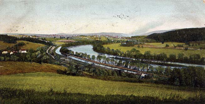
1906 - Looking east toward Bethlehem from the top of Central Park. Canal and river in view. |
©2005, 2013 Robert M Reinbold Jr